Day 4:
There was something odd about today’s route as it felt that we never really went over anything high. There were numerous ascents of 200-250 m and the same on the way back down again but nothing epic. A bit like having started a Scottish Munro day from just below the top of your first Munro of the day.
On the map it looks like one of your longer days where we would end up at the head of the Gschnitz valley. It did mean that we saw the trail ahead for a long distance every time we got over the next unnamed col. Between the cols we’d contour across what are known as Alms – high grassy plateaus above which there appeared numerous vast boulder fields.
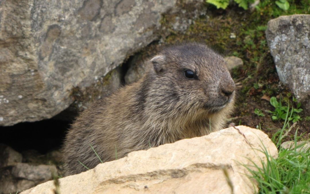
The first col was a steady climb from the Innsbrucker Hut. We had started in cloud cover but we were awarded with our first marmot sightings – a mother and her young ones which were remarkably close to the trail. Views were good across the valley to the Tribulaun. Once over the col were was a nice zig zag descent following the first of our contours before ascending the 2nd col which turned out to be equally steady.
The following descent though had some exciting technical stuff with fixed wires. Sun now came out and Iain was bounding away in the distance. In fact he had bounded that far that we couldn’t tell him that we wanted to stop for a snack break. So we stopped for a snack break. Just before this we got our first sense of the half way rush we would encounter on a daily basis from here on.
As the various walking parties departed from their respective huts around 7:30-8:30 am you got a good idea where have way was as the walkers who had left the hut you are heading for were coming through. This happened to us just as we started descending from the 2nd col. 30 min later it all was quiet again.
After our snack stop we started working our way back through some groups we had let pass while stopped. We tended to start as one of the last parties from the group. This may be because we knew that it wouldn’t take us too long – or we just faffed more.
After a bit more technical descending the trail flattened out and headed to a large boulder field. The next ascent wasn’t much in elevation but tough on big boulders. Somebody went a bit crazy on marking the path with paint though. Topping out on this col allowed us to see the hut in the distance and realizing there was another serious descent followed by a technical ascent.
The weather had turned lovely and I suggested to the other 2 that we should find a spot – lake on map – to chill in the sun for a bit. There are 2 approaches to the Bremer Hut one of which has a fairly technical description in the book and the other one being the ‘easier’ alternative. I was all for doing the easier alternative especially when we reached the path junction which described the technical option as a Klettersteig (via ferrata). Looking up we were trying to work out where the path would actually go as all we could see is this solid rock slab.
As already mentioned in one of the previous posts things often look better when you get closer so we decided to head for the lake first anyway which was on route and check out the Klettersteig after. I’d also worked out an optional escape if I really didn’t like it. Graham did mention that the alternative route didn’t look that appealing which I had to agree with.
On to the lake first though. I was more than happy to settle down without my backpack for a bit as my shoulders were hurting quite a lot. The backpack had been rubbing quite a lot on my shoulders where I’d got a sunburn on the Monday and would feel unpleasant for quite a few days to come. It did eventually improve.
It was nice, sunny and peaceful by the lake. A great place to chill although none of us did what one of the other Brits did and fully immerse in the lake for a bit of cooling off. I was more than happy to just sit on my rock.
When the wind picked up and the cloud rolled in we moved on approaching the Klettersteig. What was comforting was that the angle of the slab of rock we were due to traverse wasn’t particularly steep and thus exposure didn’t seem to be an issue. A group at started just ahead of us and looking at the climb up it didn’t seem any more difficult than some of the technical stuff we had already encountered earlier in the day. We had prepared a sling for safety which we didn’t use in the end. It turned into quite an exciting experience with the climb through a narrow cut followed by a ‘walk’ across a 45 degree slab supported by fixed wires. At the end of we basically fell into the Bremer hut (2411m) just as the rain started.
Iain arrived quite a bit earlier having enjoyed the Klettersteig that much that he did it twice but agreed that the days route was a bit meh, a bit of a transitional stage with some good views.
From the 3rd col we had heard and seen a huge rock fall on the mountain face across the valley – this was on the ridge that forms the border to Italy. Later that afternoon I was having a chat outside the hut with one of the other Brits staying there that night and we were witnessing some huge boulders crashing down. Impressive and scary at the same time. While we were admiring the rock fall others were making use of the pleasant evening sitting on various rocks admiring the views or making use of the occasional network connection to find out what was happening in the world. Graham had spotted a prime location and others soon joined him until it was time for dinner.
The Bremer Hut was the 3rd hut we stayed in and again it was different. Much smaller than the Innsbrucker Hut but in parts quite modern. A lot of the huts had been established around the turn of the 20th century and were then either extended or improved over time.
What was interesting here was they were the only hut on our walk that had catered for people carrying electronic devices and had a charging panel set up. It was bit small though so you still see mobile phones hanging precariously from plugs in various parts of the building, a very common sight in many of the huts. The dining area of this hut as with most of the others was very traditional Tyrolean with would panel, benches and tables. The meal choices usually had a similar affair too being traditional, Tyrolean food which did well to fill a hungry mountaineer’s stomach. When I had set out to book the huts I had requested half board throughout but somehow that message hadn’t made its way through to some of the huts and I think the Bremer hut may have been the first one where we did have half board.
There were various ways of sorting out the payment too from the warden keeping a tab on your purchases until the next morning including overnight stay (at Padasterjoch Haus), to everything being paid at time of purchase (at Innsbrucker Hut) and then you kind of kept a tab of your own purchases via a detailed sheet (at the Bremer Hut). It didn’t change much from these versions except at the last hut were we had to write down what we consumed on a piece of paper ourselves. Give the other guys a bit of practice writing Austrian I suppose.
Dorm room sizes varied a lot with the Bremer Huts being small – or at least the room we were in being small and with only one small window for 16 people it was rather hot. This let for another night for me with not too much sleep. Maybe I could tick that off for my UTMB training.
After a longish day today (7 hours from leaving the Innsbrucker Hut), tomorrow was looking like quite a short day – well the next 3 days were although in some cases there were possible add on.
Our totals for the day were 10.3km and 1000m of ascent.
… and here is a look back at Part one for the lead in, Part 2 for the walk to the Padasterjoch Haus, Part 3 for 1k descent and Part 4 which included 2 different parts.

Looking back at the Innsbrucker Hut

View in the direction of travel first col with the next 2 cols in view. The meadows below are the alms we would walk through to get from col to col.

Fiona tackling a river crossing

Graham on a roped section

That’s our next col!

How many markings can you spot?

Last col before the hut.

Descent with the Feuerstein mountain range in the distance and the border to Italy.

to Klettersteig or not to Klettersteig. We went left.

Chilling by the Lauterer See. That’ll be the border behind me then – Weisswand Spitze probably.

Via ferrata, here we come. It is the cleft in the rock face ahead. the Bremer hut is just above and out of sight.

The not very steep slab to cross over on the via ferrata. Nearly home and dry.

Bremer Hut

Looking down the Gschniztal from the Bremer Hut.

The rock face where we could regularly hear and witness the rock fall – to the left of the big snow field.

Looking up to the Simmingjöchl where we’d be heading the next day.